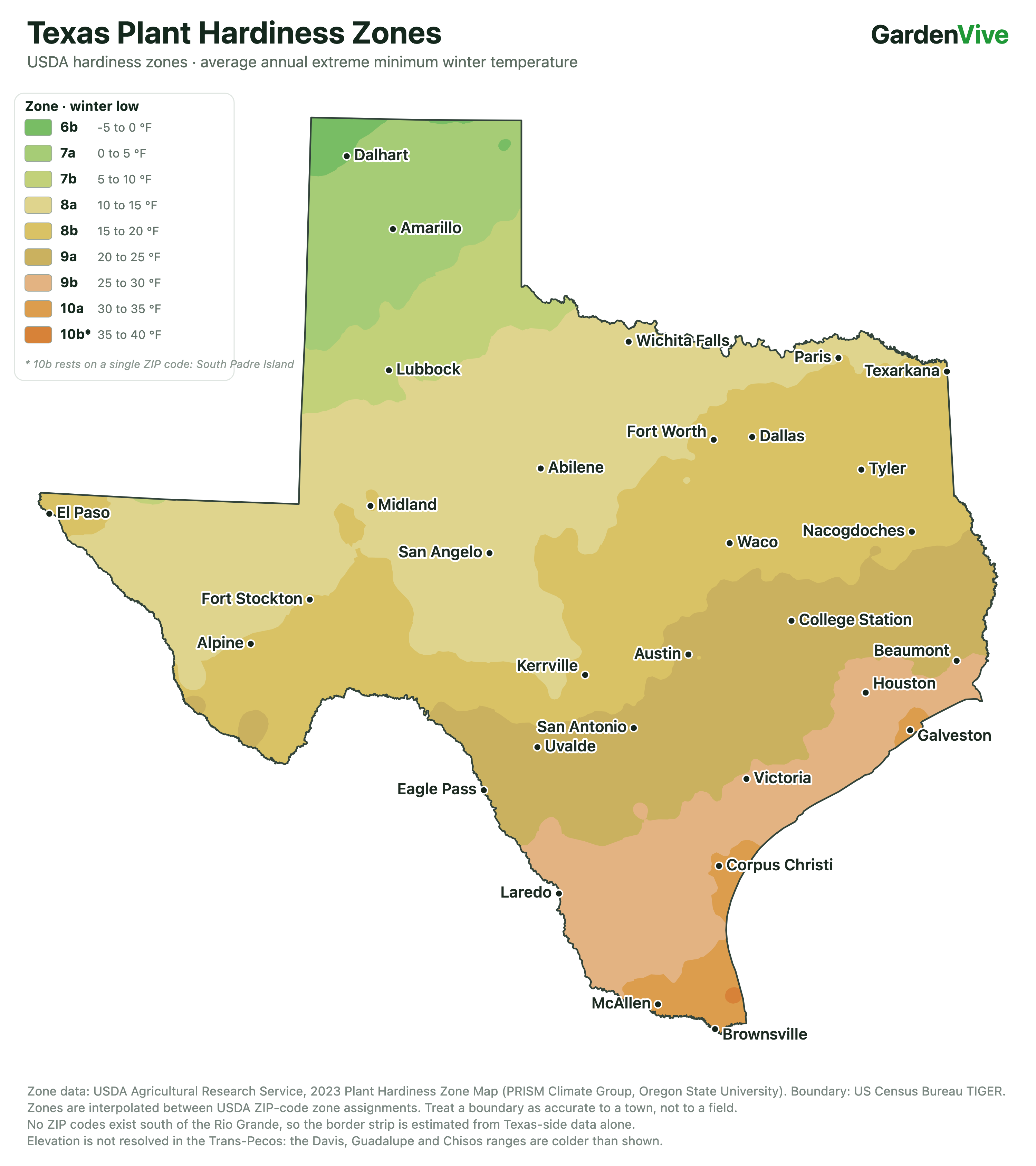
USDA Hardiness zone, or growing zone is important for every gardener. I usually like to write gardening articles, but I stopped writing for almost a month just to create this Texas USDA Zone map.
Texas is the second-largest state in the USA by total area, and it includes USDA Zones 6 to 10.
Yes, there are a lot of zones, but only zone 8 and zone 9 cover most of Texas, and the rest of the zones are in very small areas of Texas.
If you know your USDA zone, you can plant your plants at the right time.
Before you jump to your zone below, there is one thing about Texas you need to know — and it is the part most zone articles skip.
The state runs nearly 800 miles from east to west, and a single zone can stretch from pine forest all the way to desert.
Take Zone 8b. It covers about a quarter of Texas, and all three of these towns sit inside it:
| Characteristic | El Paso | Alpine | Tyler |
|---|---|---|---|
| USDA Zone | 8b | 8b | 8b |
| Winter Low | 15–20 °F | 15–20 °F | 15–20 °F |
| Annual Rainfall | 8.78 in | 15.80 in | 47.66 in |
| Elevation | 3,763 ft | 4,462 ft | 499 ft |
| Landscape | Chihuahuan desert | High desert & mountains | Piney woods |
| Soil | Alkaline | Alkaline | Acidic, sandy |
Same zone. Same winter low. But Tyler gets more than five times the rain El Paso does. And Alpine sits at 4,462 feet, where July afternoons average 89.4 °F — a genuinely mild summer by Texas standards.
So what does that mean for you? Azaleas and blueberries love the acidic, sandy ground around Tyler and will sulk and die in El Paso's alkaline desert soil. A desert agave that performs great in El Paso will rot through an East Texas winter. Both gardeners are "Zone 8b". This is what I wanted to tell you.
Here is the rule for Texas: your zone tells you what will survive the winter. Your rainfall, your soil and your summer tell you what will actually thrive. Keep that in mind as you read your zone below.
So, what should you do? I developed an app for this kind of situation. The app name is "PlantHelper by GardenVive" - Available on both App Store and Play Store and if you add plant names in the wishlist, the app will tell you what to do, considering your micro-climate detecting location.
What each zone covers (By area percentage) - Texas
I have created this table just to show you the zone-wise area coverage for Texas.
| Zone | Winter low | Share | Approx. area | |
|---|---|---|---|---|
| 6b | −5 to 0 °F | 0.7% | 2,000 sq mi |
|
| 7a | 0 to 5 °F | 7.9% | 21,300 sq mi |
|
| 7b | 5 to 10 °F | 5.2% | 13,900 sq mi |
|
| 8a | 10 to 15 °F | 29.5% | 79,100 sq mi |
|
| 8b | 15 to 20 °F | 26.7% | 71,800 sq mi |
|
| 9a | 20 to 25 °F | 17.4% | 46,900 sq mi |
|
| 9b | 25 to 30 °F | 10.5% | 28,100 sq mi |
|
| 10a | 30 to 35 °F | 2.0% | 5,300 sq mi |
|
| 10b | 35 to 40 °F | 0.1% | 100 sq mi |
|
I mostly write articles for North Texas, as my grandpa is from there, and it helps most of the Texas gardeners. North Texas is in Zone 8, and that alone covers a large part of Texas. You can check the planting chart for North Texas.
There are many ways to check USDA zones on the internet. For example, enter your ZIP code to find your USDA zone, or search for your location on Google to find your USDA zone. It's good to know your USDA zone if you are gardening.
I have checked a lot of USDA Zone maps for Texas, but I felt that there should be a simpler version of the zone map. So I drew this myself. If you like my work, please subscribe to this site; this is something that makes me smile.
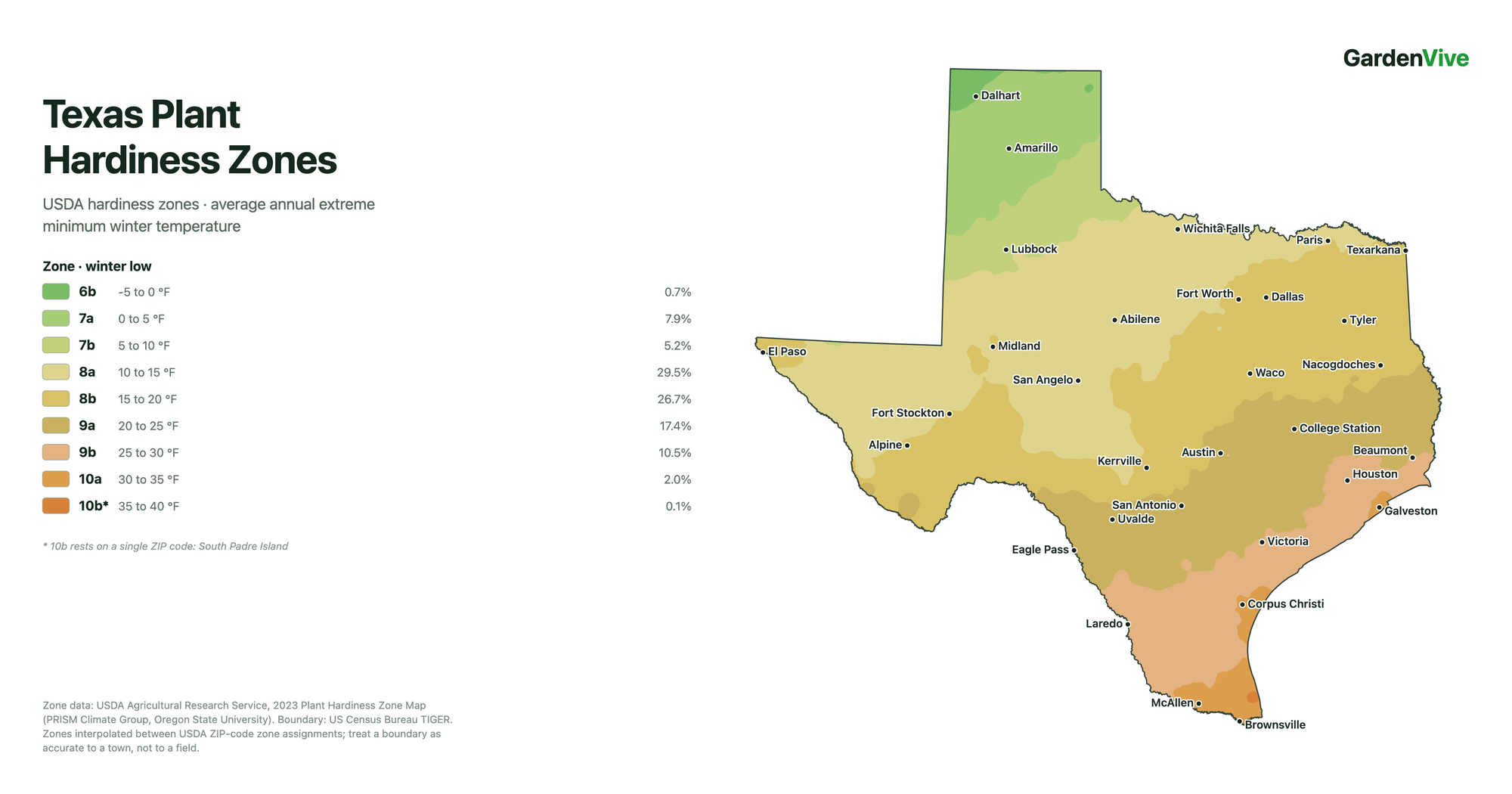
How did I make this map?
- Pulled every US ZIP code’s 2023 half-zone from USDA Agricultural Research Service’s own ArcGIS table — 40,502 records, the table behind their public map.
- Joined those to US Census ZCTA centroids, giving 4,965 classified points across Texas and well beyond its borders, so the zones stay correct at the state line.
- Interpolated between them with inverse-distance weighting on the eight nearest points, onto a grid in a Texas-centric Albers equal-area projection.
- Traced the zone boundaries as filled contours, then simplified them to 8.5% of their original vertices without moving a line by more than a third of a mile on screen.
- Clipped to the real state outline — full-resolution Census TIGER, 62,863 vertices — so the border stays sharp however far you zoom.
- Coloured with USDA’s official palette, read straight from their map renderer. Every fill byte-matches theirs.
If you are unaware of some of the above terms, don't worry; as a gardener, if you know your USDA zone, that's more than enough.
Region-wise zone explanation of Texas
Zone 6b – The Far Northwest Panhandle
| Characteristic | Details |
|---|---|
| Winter Temperatures | −5°F to 0°F (−21°C to −18°C) |
| Region | The extreme northwest corner of the Panhandle around Dalhart, at roughly 4,000 ft. |
| Share of Texas | 0.7% of Texas (about 2,000 sq mi) — the smallest zone in the state. |
| Growing Season | About 173 frost-free days. Last frost near the end of April, first frost around 20 October. |
Zone 7a – Northern Panhandle
| Characteristic | Details |
|---|---|
| Winter Temperatures | 0°F to 5°F (−18°C to −15°C) |
| Region | Much of the northern Panhandle, including Amarillo. |
| Share of Texas | 7.9% of Texas (about 21,300 sq mi). |
| Growing Season | About 189 frost-free days. |
Zone 7b – Southern Panhandle and South Plains
| Characteristic | Details |
|---|---|
| Winter Temperatures | 5°F to 10°F (−15°C to −12°C) |
| Region | The South Plains around Lubbock. |
| Share of Texas | 5.2% of Texas (about 13,900 sq mi). |
| Growing Season | About 210 frost-free days. |
Zone 8a – North Central and West Texas
| Characteristic | Details |
|---|---|
| Winter Temperatures | 10°F to 15°F (−12°C to −9°C) |
| Region | A broad band including Wichita Falls, Abilene, San Angelo and Paris. |
| Share of Texas | 29.5% of Texas (about 79,100 sq mi) — the largest zone in the state. |
| Growing Season | About 225 frost-free days, and roughly 105 days above 90°F. |
Zone 8b – The Band Across the Middle
| Characteristic | Details |
|---|---|
| Winter Temperatures | 15°F to 20°F (−9°C to −7°C) |
| Region | Dallas, Fort Worth, Waco, Tyler, Texarkana and Nacogdoches in the east; Midland, Fort Stockton, El Paso and Alpine in the west; Kerrville in the Hill Country. |
| Share of Texas | 26.7% of Texas (about 71,800 sq mi). |
| Growing Season | About 245 frost-free days. |
Zone 9a – Central and South Central Texas
| Characteristic | Details |
|---|---|
| Winter Temperatures | 20°F to 25°F (−7°C to −4°C) |
| Region | Austin, San Antonio, College Station, Uvalde and Eagle Pass. |
| Share of Texas | 17.4% of Texas (about 46,900 sq mi). |
| Growing Season | About 273 frost-free days, and roughly 121 days above 90°F — the hottest zone in the state by that measure. |
Zone 9b – Upper Coast and the Laredo Country
| Characteristic | Details |
|---|---|
| Winter Temperatures | 25°F to 30°F (−4°C to −1°C) |
| Region | Houston, Beaumont and Victoria on the humid upper coast — and Laredo, which is semi-arid. |
| Share of Texas | 10.5% of Texas (about 28,100 sq mi). |
| Growing Season | About 309 frost-free days. |
Zone 10a – Rio Grande Valley and Lower Coast
| Characteristic | Details |
|---|---|
| Winter Temperatures | 30°F to 35°F (−1°C to 2°C) |
| Region | Brownsville and McAllen in the Valley; Corpus Christi and Galveston on the coast. |
| Share of Texas | 2.0% of Texas (about 5,300 sq mi). |
| Growing Season | Effectively year-round, and roughly 139 days above 90°F. |
Zone 10b – The Southern Tip of the Coast
| Characteristic | Details |
|---|---|
| Winter Temperatures | 35°F to 40°F (2°C to 4°C) |
| Region | A sliver at the southern tip — South Padre Island, Port Isabel and the lower Laguna Madre shore. |
| Share of Texas | 0.1% of Texas (about 100 sq mi) — the warmest and smallest zone in the state. |
| Growing Season | Year-round. |